Teledyne Oceanscience Supplies Innovative rapidCAST to TerraSond for Major Hydrographic Project
CARLSBAD, Calif. – September 29, 2015 – Teledyne Oceanscience supplied world-leading geospatial company TerraSond Limited with rapidCAST, a new innovative automated underway profiling system. According to TerraSond, the product was used in a major hydrographic project completed for NOAA’s Office of Coast Survey in the Bering Sea in northwestern Alaska for the purpose of nautical chart.. read more →
SVOA, NOAA & The Coast Guard team up to re-survey Arctic waters
“As Arctic commerce heats up, more ships are expected to pass by the Aleutian Islands, through the Bering Strait and north into the Chukchi Sea. The U.S. Coast Guard, which is assessing a possible designated Arctic shipping route in those waters, has teamed up with the National Oceanic and Atmospheric Administration to improve navigational knowledge.. read more →
SVA – Hydrographic Survey & Tide Station Installation Project
Support Vessels of Alaska, Inc. provided vessel support for a full to partial bottom coverage hydrographic survey for nautical chart updating near False Pass, Alaska. Centered on Bechevin Bay, the area included the approaches from the Bering Sea and Pacific Ocean including Isanotski Strait. Singlebeam data was collected in the 4m to 8m depth range,.. read more →
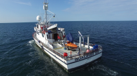
Qualifier 105 Terrasond Chukchi Sea Red Dog Mine Survey
The Qualifier 105 operated in the Chukchi Sea this past summer. NOAA Ship Fairweather was in for repairs and the Qualifier 105 was contracted by Terrasond for the essential survey work needed in the approaches to read more →